Cirencester is well known for its historical and architectural heritage. Less so, for its green spaces and wildlife. We think this walking route around our town will surprise you. The green corridors and spaces you go through are an important amenity for the people of Cirencester and its visitors. They provide an opportunity to get closer to nature with all the health and well being benefits that brings. Though bounded by roads and building development, the River Churn provides a rich, linear habitat for a good variety of animal species including Kingfisher, Water Vole and Otter. City Bank Nature Reserve.
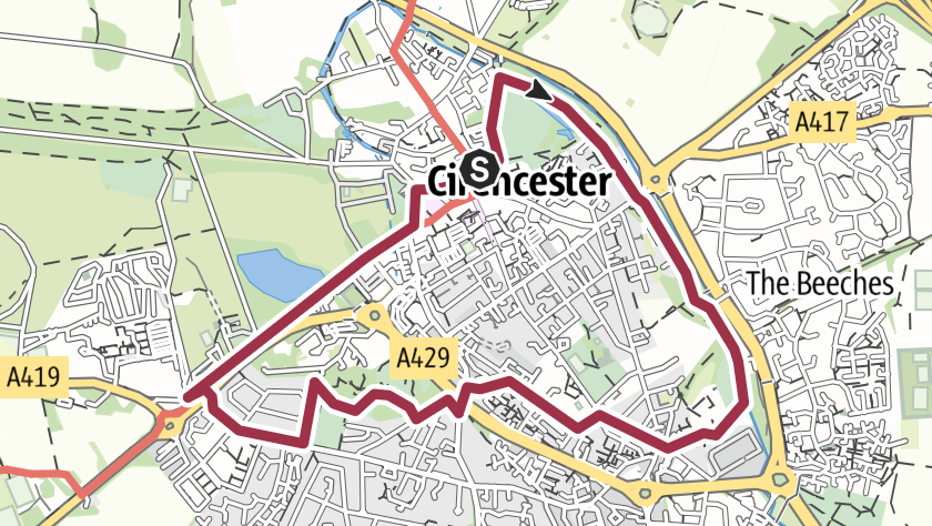
The walk starts at West Market Place, to the rear of the Parish Church. Enter the Abbey Grounds and follow the main path, turning left where the path splits in two (1).
The C12th Norman Arch is ahead (2), the only surviving visible building from the Augustinian Abbey. Take the path that passes the children’s playground on your left and the lake on your right and enjoy the views across the lake of the Abbey Grounds and Parish church. Continuing on this path you will pass the earthwork remains of the Roman Wall of Corinium. Continue into the residential area (3).
Stay on the left hand pavement and follow this road (Corinium Gate) to the junction with London Road. This is a busy road and best crossed away from the roundabout on the left. Once crossed, you continue along Beeches Road crossing to the left side pavement with the public car park on your right (4).
Follow this for a few minutes and continue on the foot path that runs parallel to the road. This will take you past the old bridge over the River Churn. Continue on, climbing the steps to emerge back on the road.
Take care crossing here on the bend. Go straight over the road and follow the tree lined path ahead of you (5). Continue down the slope to the bottom, passing City Bank Nature Reserve on your right. You will come to the junction of three paths (6).
The middle path will take you along the top of the earthworks of former Roman town wall and the right path will take you down in to the open green space of the nature reserve, accessed through a gate.
Either way you cross the stream, to emerge into City Bank Road. Follow this to the junction,turning right on to Watermoor Road. Passing Watermoor Corner, continue down Watermoor Rd and turn in to Stepstairs Lane then turn right on to Trinity Road.
An alternative route is to stay on Watermoor Rd until you reach Holy Trinity Church and you can cut through the churchyard to Trinity Rd (7).
Stay on this following it as it curves left and up to meet Sheep Street, passing the Old Lock Up on the way (8). Turn left and go over the bridge over the dual carriage-way. Turn sharp right immediately you have crossed the bridge into Cotswold Avenue following this round to the left (9), where you will see the Georgian era Obelisk on your right (10). Continue to a gate signposted to the Roman Amphitheatre with a gravel path beyond. Take this, following it down through the green space and the amphitheatre on your right (11).
Follow the track around to the left and then right to the entrance into Querns Wood, a community woodland (12). Go through the woodland to a junction with other paths, turning left where signposted Four Acres. This takes you up some steps (not suitable for wheelchairs). You emerge at the edge of Four Acre Field and continue straight on, exiting the field on to Chesterton Lane.
Keep on the right hand pavement and follow the lane (13) to the end. The A419 is ahead and you bear right, using the subway to get to the other side). Your route back into town follows this path nearly all of the way (14), with Cirencester Park on your left for most of it. Worth a detour and accessed about a third of the way down through a permissive gate (8am – 5pm charges apply).
When you reach the edge of the centre of the town keep left, following Park Lane (15), past the Corinium Museum (16) and bear left along Black Jack Street (17). This brings you back to the Market Place and Parish Church.
Visit the Local Information Centre at our own Town Hall in Dyer Street www.cirencester.gov.uk
Info
Difficulty
Easy
Length may vary, but the terrain is mainly flat
Moderate
Includes some hills and some rough ground
Strenuous
May be rough underfoot and ascents and descents may be steep
Info Suitability
Mobility scooter
These routes are more likely to be suitable for standard mobility scooters (not all-terrain models). They may feature flatter or smoother terrain.
Pushchair friendly
These routes are more likely to be suitable for prams or pushchairs. They may feature flatter or smoother terrain.
Stile free
These routes do not have stiles. Please note that they may have kissing gates or footbridges, and/or steep, narrow or muddy sections.
Trampers
These routes are more likely to be suitable for all-terrain mobility scooters. Please ensure you have plenty of battery and are well prepared for any routes.
Wheelchair friendly
These routes are more likely to be suitable for standard wheelchairs (not all-terrain models). They may feature flatter or smoother terrain.