Distance
6 miles / 9.66 km
Duration
3 to 4 hours
Difficulty
Moderate
Mobility aid rating
Stile free
Shape
Circular
Start
Address
OS Grid Ref
ST753643
What3Words
Public toilets
Southgate (city centre), Walcot Street near the library, Batheaston (20p)
Refreshments
Shops and cafés of Bath city centre and Batheaston. The Pump Shed café (seasonal opening hours), The Holburne Museum café, The George Inn, Bathampton and Morrison’s.
Travel Info
Visit travelinesw.com. Bath Spa train and bus stations at the start. Pay and display city centre car parks. Alternatively start and finish in Batheaston where there is a car park and regular buses and join the route at point 3.
Navigation
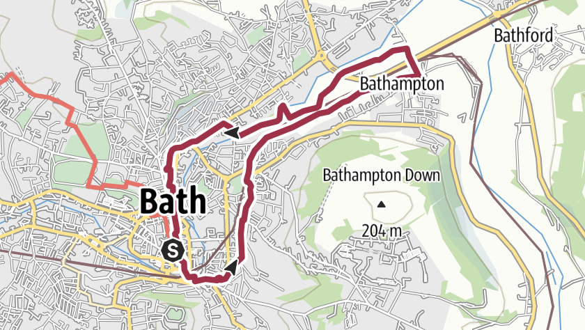
With your back to the train station main exit turn left, passing an old telephone box which is now a planter! Pass through the tunnel (under the railway tracks) and on the other side turn left, along the pavement which runs alongside black railings until you reach Halfpenny Bridge across the River Avon.
Cross the bridge and then turn immediately left onto the pavement of Rossiter Road. Continue ahead until you need to cross a minor access road where you should see the Kennet & Avon Canal and a pair of lock gates.
Cross over the access road to join the paved path parallel to the lock. You will have the canal on your left and the road on your right.
Continue along the path, also known as the Kennet and Avon Canal Trail, under a bridge and then where the path forks just before another bridge, take the right-hand fork which slopes up to the road 1 . Turn left to cross over the canal, then use the pedestrian crossings to cross the road, back to the canal, follow the tow path with the canal on your right. Continue along the tow path until it meets a road (Pulteney Gardens).
Carefully cross the road to continue on the tow path. Pass The Pump Shed café next to the Pumphouse Chimney, which is all that remains of the pumping station that was here in the 1830s, housing a coal-fired pumping engine. The pump helped supplement the water supply to the nine mile section of canal above Bath. Continue following the canal, passing more locks, until you reach a stone bridge. Before passing under the bridge, look to your left and take the flight of stone steps up to street level.
At the top, turn right to pass over the bridge, then use the zebra crossing to cross the road (Bathwick Hill) before continuing down to the canal once more, which is now on your left 2 .
Continue until another bridge, it looks as though a large Bath stone building is on top of the bridge. This is Cleveland House and was the Headquarters of the canal company. Follow the tow path up, passing this building, to the main road. Turn right and before the entrance to Bath Spa Hotel, carefully cross the road into Sydney Gardens. Where the path forks, take the left fork and follow it along until you reach a bridge with white railings on your left. Use this bridge to cross over the canal and into the main part of Sydney Gardens, which are well worth exploring a little. You can also reach the Holburne Museum easily from here.
When ready to continue on the walk go through the white metal gates, which were just to your right as you crossed the bridge, on to the tow path. Turn left to walk under the bridge.
Pass through a tunnel and continue along the tow path with the railway down below you on your left and the canal on your right. Pass a wooden pedestrian bridge on your right then pass under stone bridge 184. Continue along the tow path, enjoying the views and glimpses into canal life.
After a while, houses start to appear on the opposite side of the canal, then you pass in front of a row of attractive stone cottages on your left. Just beyond these, before the next bridge, turn left down a short flight of steps. You can now follow the Circuit of Bath way markers, past the George Inn on your left and St. Nicholas’ Church on your right, over the railway tracks then the A4. The Circuit of Bath is a 20.5 mile circular route around the city which can be walked in sections or in one go. Walking guides, like this one are available to download.
Soon after this, the Circuit of Bath arrows send you right, however, look for a driveway on the left 3 . Go through the metal gate next to a cattle grid and walk up the drive, until just before a second cattle grid. At this point there is a metal gate on your right, which leads onto a footpath in the meadow beyond. Go through the gate and follow the path first along the left hand field edge, then follow the line of pylons past the buildings of New Leaf Farm and then under the A4. This land, Bathampton Meadows, was acquired by the National Trust in 2022.
The path then continues running parallel to the pylons for a short while. When the path forks, take the left fork towards the corner of the meadow, by the railway embankment. Pass into the next meadow via a stone track and then follow the path, alongside the railway embankment, until a metal gate. Go through the gate and follow the path to a T-junction, with a railway bridge on your left. Turn right and follow the tarmacked path over the River Avon via Grosvenor Bridge which replaced the original 1830 bridge in 1929 4 .
Once over the bridge, turn left and take the path into Kensington Meadows. Immediately after the wooden gate, turn left down some steps marked by a finger post to the “Riverside Walk”. Where the path forks, take the right, more major path which then runs parallel to the river.
The path then does a switch back before abruptly ending at the edge of Morrison’s car park. Carefully cross the car park, then use the pedestrian area around the building to pass the front of the shop until you reach a zebra crossing. Use this to cross the minor road and follow the pavement up to the main road (London Road). At the T-junction, turn left and use the crossings to reach Norland College, a world-renowned college for early years studies.
Stay on the pavement of London Road, passing 4 large metal planters. Continue up the street passing the Cleveland Reach road sign to reach the Cleveland Place junction. Turn right to use the pedestrian crossing here, to cross the main road (London Road has now turned into Walcot Terrace) to a flight of stone steps. Turn left to go up the steps onto Walcot Parade. Enjoy the traffic free pavement here until it pops out at a road, cross the road and into Hedgemead Park.
Follow the main path up the steps through the park, or stop to explore a while. Keep left to pass an ornate fountain topped with a golden eagle and then the band stand on your right. Keeping the playground immediately on your right before following the path as it dips down, and then up to the exit on Guinea Lane. Carefully cross the road and take the flagstone alleyway past Guinea Lane Nursery to ‘The Paragon’ below. Turn right and walk along the raised pavement passing one set of steps down to the road, then taking the ramp at the next opportunity down. Take care to cross the road here 5 , then continue straight ahead down some steps beyond three black bollards to Walcot Street below.
Cross Walcot Street, then turn right to walk along the pavement back towards the centre of Bath. Take a moment to turn around and look at the artwork and stone faces adorning the Great Wall of Walcot, stop at the Wild Walcot garden, a community led project to brighten a previously derelict piece of land. Carry on walking into the city centre, passing St. Michael’s Church on your right and then Waitrose on your left. Continue straight until you reach Bath Abbey. Turn to the right and skirt around the front of the Abbey, through Kingstone Parade, keeping the Roman Baths on your right, then onto Abbey Street.
Pass a huge London Plane tree, then go under a stone arch and follow the road as it bears right. At the T-junction turn left and walk down Stall Street until you reach the pedestrian area. Take St. Lawrence Street to Southgate Place. Turn right along Newark Street, keeping Boots on your right until you meet the main road opposite Brunel Square and the train station, where you started.
Info Difficulty
- Easy
- Length may vary, but the terrain is mainly flat
- Moderate
- Includes some hills and some rough ground
- Strenuous
- May be rough underfoot and ascents and descents may be steep
Info Suitability
- Mobility scooter
- These routes are more likely to be suitable for standard mobility scooters (not all-terrain models). They may feature flatter or smoother terrain.
- Pushchair friendly
- These routes are more likely to be suitable for prams or pushchairs. They may feature flatter or smoother terrain.
- Stile free
- These routes do not have stiles. Please note that they may have kissing gates or footbridges, and/or steep, narrow or muddy sections.
- Trampers
- These routes are more likely to be suitable for all-terrain mobility scooters. Please ensure you have plenty of battery and are well prepared for any routes.
- Wheelchair friendly
- These routes are more likely to be suitable for standard wheelchairs (not all-terrain models). They may feature flatter or smoother terrain.